

Ogun on Red Alert as Heavy September Rains Loom, NEMA Tests Flood Rescue Plan
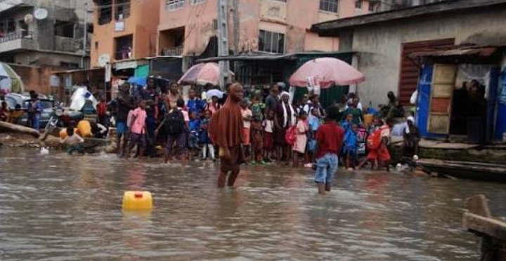
Global Mirror News reports that Ogun State has stepped up its flood preparedness as authorities brace for intensified rainfall in September, with the National Emergency Management Agency (NEMA) and the Ogun State Emergency Management Agency (OGSEMA) conducting a full-scale simulation to test the state’s ability to respond to a major flood disaster.
The latest development comes days after the Ogun State Government issued a fresh flood alert on Tuesday, September 1, 2026, warning residents in vulnerable communities to remain vigilant and relocate to safer areas where necessary as the second phase of the 2026 rainy season gathers momentum.
The warning followed forecasts by the Nigerian Meteorological Agency (NiMet) indicating that Ogun is among the states expected to experience heavy rainfall during the year.
According to the State Government, the first phase of the rainy season, which lasted from mid-March to July 2026, recorded intense rainfall and isolated flash floods in parts of Ogun, although the impact was relatively limited.
Authorities attributed the comparatively low impact to measures including public awareness campaigns, regular maintenance of rivers, streams and drainage channels and improved waste-management operations.
September rainfall raises fresh concern
The State’s latest warning has become particularly significant as September rainfall intensifies.
Ogun Commissioner for Environment, Ola Oresanya, said NiMet’s projections indicate that the state could record about 360mm of rainfall in September, increasing the possibility of riverine and coastal flooding in vulnerable areas.
The Government also warned that prolonged rainfall, possible controlled water releases from Oyan Dam and tidal fluctuations could combine to slow the movement of water through the Ogun River system, temporarily saturating wetlands and floodplains.
Residents in vulnerable locations including Isheri, Arepo, Mawere, Magboro, Akute, Warewa and parts of Abeokuta have therefore been urged to remain alert and move to safer locations whenever necessary.
The warning also covers several coastal and riverine communities, including Makun-Omi, Iwopin, Oni, Ifaara and Igele in Ogun Waterside; Ebute-Imobi in Ijebu East; Tungeji Island and Agosasa in Ipokia; and communities located along the Ilo and Iju rivers.
Fish farmers operating around floodplains and river corridors have equally been advised to harvest their stocks early to minimise potential losses.
NEMA conducts emergency simulation
Against this backdrop, NEMA on Thursday, September 3, 2026, conducted a full-scale flood disaster response simulation in Abeokuta, bringing together emergency responders and other critical stakeholders.
The exercise, held around the Apo River area of Owu, Abeokuta, was designed to test emergency plans, improve communication and strengthen coordination among agencies responsible for disaster management.
NEMA Director-General, Mrs Zubaida Umar, stressed the need for stakeholders to strengthen preparedness and coordination in order to minimise the impact of flooding.
The Agency said the simulation was intended to enhance coordination, communication, interoperability and efficiency among institutions involved in disaster-risk management.
Representing the Ogun State Government, Deputy Governor Noimot Salako-Oyedele said the exercise was particularly important because the 2026 Seasonal Climate Prediction and Annual Flood Outlook had identified Ogun among areas facing significant flood risks.
She said the exercise provided an opportunity to determine how quickly emergency responders could mobilise, how effectively information could be communicated and how rapidly assistance could reach affected communities during an actual disaster.
‘Flood preparedness is everyone’s responsibility’
The Deputy Governor warned that disaster management should not be regarded as the sole responsibility of Government Agencies.
She urged residents to take early warning messages seriously, avoid building on waterways and drainage channels, stop indiscriminate dumping of refuse and cooperate with authorities whenever evacuation or other preventive measures become necessary.
She also identified traditional rulers, community leaders, Local Government authorities, security Agencies, health workers, volunteers and the media as essential partners in ensuring that critical information reaches residents before disaster strikes.
According to her, the real value of the simulation would be measured by whether lessons from the exercise resulted in faster, safer and better-coordinated responses when a real emergency occurs.
She assured residents that the Ogun State Government would continue to work with NEMA and other relevant agencies to strengthen disaster preparedness and protect lives, property and vulnerable communities.
NEMA warns against complacency
Representing the NEMA Director-General at the exercise, the agency’s Director of Search and Rescue, Commodore Nature Usman, called for stronger coordination, communication and response mechanisms.
Usman described flooding as one of Nigeria’s most recurrent and destructive natural hazards, noting that its consequences go beyond loss of lives to affect livelihoods, homes, roads, infrastructure, the environment and entire communities.
He said the increasing frequency and severity of flood events made early warning, anticipatory action, preparedness and rapid response essential.
He also referred to the devastating flooding in Nepal in late August 2026 as a reminder of how quickly flood disasters can overwhelm communities.
The Nepal disaster had by September 1 claimed more than 1,000 lives across Nepal and Tibet, with thousands of people still reported missing, underscoring the need for effective early-warning and rescue systems.
Usman said exercises such as the Ogun simulation enable emergency agencies to identify weaknesses in their plans before lives and property are placed at risk.
He emphasised that preparedness was critical to saving lives, adding that effective disaster response depended on how well agencies planned, trained, communicated and worked together before an emergency.
Nigeria’s wider flood risk remains high
The Ogun alert forms part of a broader national flood preparedness effort.
The 2026 Annual Flood Outlook released earlier in the year identified 14,118 communities across 266 Local Government Areas in 33 States and the Federal Capital Territory as being at high risk of flooding.
Another 15,597 communities across 405 LGAs in 35 states were placed in the moderate-risk category, while 923 communities in 77 LGAs were projected to face minimal flooding.
Ogun is among the states listed in the high-risk category.
In a fresh national update published by NEMA on September 6, 2026, the agency stressed that flood preparedness must go beyond issuing warnings. It called for translating forecasts into practical measures such as identifying vulnerable communities, communicating risks clearly, preparing evacuation routes, positioning rescue equipment and moving residents before rising water makes evacuation difficult.
NEMA also said it had strengthened its emergency coordination structures, including the National Emergency Operations Centre, to improve the collection, analysis and processing of reliable flood information and support coordinated decision-making.
NEMA steps up nationwide monitoring
The latest National developments indicate that authorities are maintaining heightened vigilance as the peak flood-risk period continues.
On September 5, 2026, NEMA was reported to be closely monitoring water levels at Cameroon’s Lagdo Dam because of the potential flood risk along the River Benue.
This adds another layer to the Country’s flood preparedness efforts, particularly for communities along major river systems.
For Ogun residents, however, authorities have continued to stress that early action remains the most effective protection against avoidable flood losses.
Global Mirror News therefore urges residents, particularly those living close to rivers, drainage channels, wetlands and floodplains, to monitor official warnings, keep drainage routes free of refuse, avoid crossing flooded roads and waterways and relocate promptly when advised by emergency authorities.
The message from Government and emergency Agencies is clear: the purpose of the current simulation is to prepare for a disaster before it happens, not to wait until floodwaters have already taken over communities.